| Topic: |
Exploiting spatial gradients – An introduction to GIS-based approaches using raster data |
|
| Instructor: |
Dr. Janek Walk1, |
|
| Date: | 23th Jan 2026 | |
| Time: |
09:00-18:00 CET (incl. 1 h lunch break and smaller breaks) |
|
| Location: |
Zoom |
Short abstract with content covered during RTD:
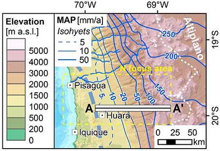
The Atacama Desert but also Namibia are our playgrounds in the CRC 1211. Both regions are characterized by prominent topographic, climatic, and biologic gradients, all expressed in spatial differences. This course offers an introduction to the spatial analysis of raster geodata using geographic information system (GIS) software. Open-source geodata – in specific, digital elevation models, climate raster data, and multispectral satellite imagery – will be quantitatively analyzed along transects using the example of the Atacama Desert. This course specifically targets PhD students with no or only little experience in GIS, yet also more experienced users might get to know some new data and tools.
At the end of the course, participants will
- have an overview (only selection!) of open-source global raster geodata
- know how to perform descriptive geostatistical analyses along transects using a GIS
- be familiar with the cartographic basics in GIS to illustrate results as a map
Previous experience:
No previous experience with GIS software is required. The course, however, might also be interesting/relevant for researchers with some GIS skills.
What you need to participate in the course:
It is recommended to install a current version of ESRI ArcGIS Pro. The analyses will be presented using ArcGIS Pro. The course content is transferrable to other GIS software (e.g. QGIS); however, this might be challenging for non-experienced users.
[@Organizers: Please check the ArcGIS software availability preferably provided via the University of Cologne]
Maximum number of participants: 20 (first come, first served).
PhD candidates of the CRC have priority to participate. Left spaces can be filled up by interested Postdocs of the CRC (write an email beforehand, if interested).
Registration: Register by e-mail to This email address is being protected from spambots. You need JavaScript enabled to view it. 28th Nov 2025.
[@Organizers: to have sufficient time to organize the software licences; if that can be done easily/quickly by the UzK, the deadline can be shortened up to Friday, 02.01.2026]